I’m Sarah, the project manager for the Leven Carrs Wetland project near Beverley in East Yorkshire.
In this post, I’ll shine a light on our Landscape Recovery project.
We want to transform the area into a landscape-scale, dynamic wetland which is home to an abundance of wildlife and sits alongside sustainable farming practices and food production.
Leven Carrs is in East Yorkshire, approximately 10 miles north of Hull and the Humber estuary. As well as being one of the UK’s busiest ports, it is an internationally important site for wildlife.
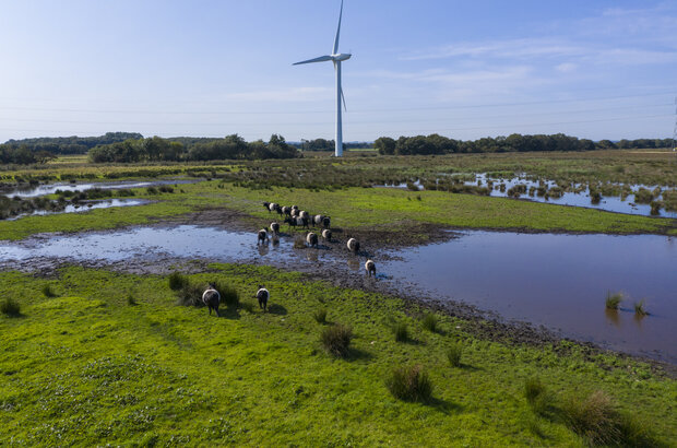
Sitting in the River Hull floodplain, Hall Farm, the site of the Leven Carrs wetland, was once a vast expanse of wet grassland, marsh and open water.
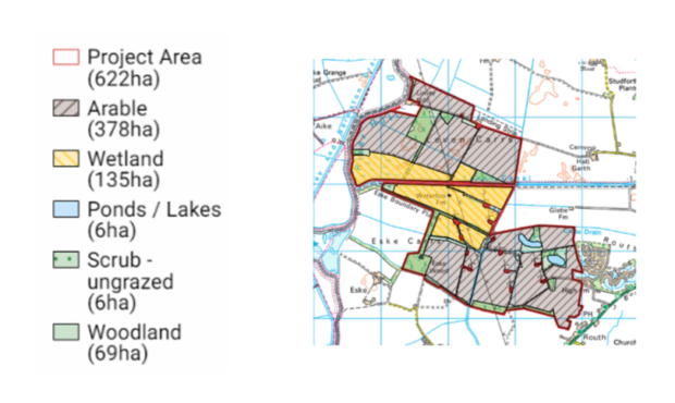
Following a long history of land use for agriculture, the site is now a mix of drained high input arable farmland and 135 hectares of wetland where water levels are managed through a system of pumps.
It’s a complex site with peat soils, a 12-turbine windfarm and a Site of Special Scientific Interest (SSSI) running through the boundary.
Over the years, we’ve worked to reverse declines in biodiversity with the help of Countryside Stewardship, but through Landscape Recovery we seek to broaden our ambition.
Understanding the full potential of the land
The great thing about Landscape Recovery is that it gives us the chance to really understand the full potential of the land.
It enables us to try new things and identify which actions work best on the land to deliver the outcomes we want: sustainable water management, carbon storage, biodiversity enhancement, nature recovery, climate adaptation, social benefits, employment opportunities, diversifying food production and more.
I mentioned there is already a wetland on the project site, so you might wonder why we want to create more.
More, better quality wetland habitats including reedbed, pools, wet grassland and small carr woodland (wet woodland characterised by willows, birches and alder that thrive in soils with poor drainage) would provide homes for wildlife, including the threatened water vole (more on that later), space for people to enjoy and grazing land for farming livestock.
The site has a range of natural hydrological and topographical features which make this a perfect place to work with nature.
For example, the geology, elevation and landform of the site means water can be stored easily. This means the land is well suited to become a wetland habitat, but it is more of a challenge to farm with an arable rotation.
Farming
Farming in this area is central to the local economy and community. It’s also the mainstay of our business in the area, so it will always be part of our plans.
The farm is currently an intensive arable farm, but there are other exciting options which could allow us to farm in a more sustainable, environmentally-friendly way while still producing food and creating jobs.
For example, livestock farming for sustainable meat and crops such as lettuce or watercress which prefer wetter soil around the wetland sites.
Other products from 'wet farming’ include bioenergy, building materials, clothing, and biodegradable food packaging to name a few.
Rewetting peatland for wet farming also has wider environmental benefits. When peatlands are drained, they emit carbon due to the decomposition of organic matter. That’s why damaged peatlands are a major source of greenhouse gas emissions.
If we wet farm our peat soils we can help peat to restore and accumulate, reducing carbon emissions.
People
The wider area’s rich history, beautiful landscapes, and miles of walking paths make it popular with locals and visitors alike. We’re pleased to be a small part of this tapestry.
The project will require a large team of local employees working together to support the wetland and farming enterprises, boosting economic resilience, as we tackle the challenges of climate change.
Tourism and recreation opportunities including public access routes, visitor infrastructure, and green social prescribing in conjunction with hospitals and doctor’s surgeries are all in the mix as we investigate what’s possible.
We hope to create a green space for locals to visit, enjoy, volunteer and be proud of. The social benefits of the project are as important as any other.
Biodiversity
Healthy wetlands support an abundance of plant life. They also provide shelter, nurseries and breeding grounds for wildlife.
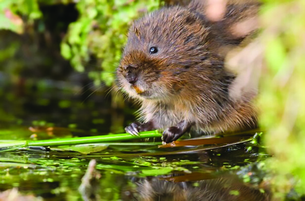
As a species recovery project, several species are predicted to benefit from our proposals, but our target species is the water vole.
The water vole has declined by 94% since the 1960s. This is due to habitat degradation and fragmentation leading to the isolation of populations. This issue is further exacerbated by American mink predation.
By improving the network of ditches, we can create a safer habitat mosaic to attract more water voles into the area, as well as boosting their breeding success.
With the project area linking the nationally important protected sites of the river Hull, Leven Canal, Pulfin Bog and Tophill Low, and the internationally important Humber estuary to the south, it’s also a potential hotspot for breeding waders. It's also a stone’s throw away for wintering and passage birds.
Many more insects, mammals and freshwater species will also benefit from the plans.
Other ecosystem services
We hope to achieve great things for both wildlife and people, but there are wider, and perhaps less obvious, benefits that our project will create.
For example, carbon storage and flood risk management could also contribute to the UK’s broader climate change commitments, not to mention a drop in emissions as we change the way we farm.
Our progress
We’re in the development phase at the moment. We have until 31 December 2024 to complete our feasibility studies. We're surveying what we have on site currently and its condition. This includes habitats, species, water quality, water sources and carbon storage.
We're working with experts who use this data to design a landscape-scale wetland and create a robust business model which is based on the site’s potential ecosystem services.
Some of the work is pretty sizeable, for example, sinking 30 metre boreholes, measuring peat depths over the entire site, or laying a thousand water vole rafts. When the water voles run across the rafts, they leave droppings and we get excited because it means they’re there!
Other work is less gruelling. For example, I'll be in my wellies collecting water samples from the drains, ditches and pools on site – with the odd bit of bird watching in between!
As we conduct studies on the site, we’ll learn more about what’s possible, and we’ll be able to make informed decisions about the land use and management at Hall Farm.
Our partners
A steering group of experts from governmental and non-governmental organisations provide advice and guidance to the project through monthly steering group meetings.
We’ve been very fortunate to have their input and their expertise is of enormous value.
They are representatives from Albanwise Farming Ltd, Natural England, the Environment Agency, Forestry Commission, Beverley and North Holderness Internal Drainage Board, Yorkshire Water, Yorkshire Wildlife Trust, East Riding of Yorkshire Council and Albanwise Wallace Estates Ltd.
We plan to work with them throughout the project and, if successful, into the next phase of the scheme when we get to put our plans into action.
The future
If we’re successful and we progress to the next stage, the implementation phase, we’ll need to make sure we can fund the work from 2025 well into the future (30+ years).
Securing private finance is crucial to the success of the project so we’re working hard to do just that. Conversations with a range of organisations are in the early stages and we are always keen to hear from people interested in supporting the restoration of this special landscape.
If you have any questions about our project or Landscape Recovery in general, leave a comment below.

15 comments
Comment by Paul Bishop posted on
What a great project. I was one of the founder members of the TopHill Low nature reserve in the 1970’s which was then a wildlife oasis in an agricultural wilderness. Land at that time was still being drained and I can remember when the fields down to the river from Ladysmith which supported many winter migrants was drained off.
To see what has happened since and with all the other local projects was just an elusive dream in those days. It’s certainly a dream come true to see the return of so many wetland species. Well done keep up the good work.
Comment by Karyn Murby posted on
Hello Sarah,
Could you please get in touch? Molescroft Wildlife Network is a community wildlife group in Beverley. We have contacts in Leven which may be helpful. We are in your catchment area and are exploring how we can improve connectivity, geographically, species and habitat and also community based.
Molescroftwn@gmail.com
Molescroftwn.org
Your project looks wonderful!
Kind regards
Karyn Murby
Comment by Sarah Stewart posted on
Hi Karyn,
Thanks for visiting the blog and getting in touch. I've passed your message on to Sarah.
Best wishes,
Sarah
Comment by George Swallow posted on
Your project looks to have some good environmental benefits. I have few questions on your proposed project:-
Do you plan to turn all the 622 ha project area into wetlands?
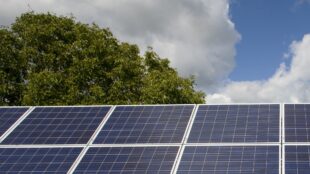
Are you aware of the proposed Peartree Hill Solar Farm, which would be in the next field to the north of project area and how would this impact your wetlands project?
How will your project help to reduce the risk of flooding in Leven, which suffered severe flooding in June 2007?
Comment by The Project Team posted on
Hi George,
Thanks for your comment and questions.
This first stage of the project is to get an in-depth understanding of what the land is capable of and what is feasible. We're currently scrutinising the area's natural landscape (features and topography) to influence which bits could be wet and which bits need to be drier. Ideally, a mix of wetland habitats: fen, reedbed, wet grassland, etc with some areas more suited to public use, is what we're after, and this applies to the total 622 hectares.
We are aware of the Peartree Hill Solar Farm. We do not foresee any negative impacts from the plans on our own project, however, we will monitor the project closely.
We are currently carrying out a detailed flood risk assessment for the site as it exists now and will repeat this when we have a proposed wetland design. This is to ensure that we will not exacerbate the risk of flooding for the area - this is something we take very seriously - if the risk assessments show an elevation in flood risk we will amend our plans accordingly.
However, it is likely the risk assessments will show there will be natural flood management benefit to the local area. Sitting on peat soils in a river floodplain, the area wants to be wet. As a vast wetland the soils would act as a sponge holding the water back from the surrounding fields.
Thanks again for visiting the blog.
Best wishes,
The Project Team
Comment by Tony William Powell posted on
This is a very informative post; thank you. Additionally, with 32 likes and counting, it seems DEFRA could be onto a winner with the public with these "Landscape Recovery" projects. Let's hope they continue to deliver many benefits in the years ahead for everyone and everything.
Comment by Sarah Stewart posted on
Hello Tony,
Thank you for visiting the blog and for leaving such a positive comment!
We're glad you found the post informative. We plan to publish spotlight posts every month to show the range of projects, landscapes and activities underway. The scheme supports outcomes that take a long time to deliver, such as peatland restoration, woodland management and habitat restoration, so there will be no shortage of stories to tell.
The second round of the scheme has just closed and the successful projects will be announced soon. A third round is also confirmed for 2024, so do look out for updates!
Best wishes,
Sarah
Comment by Bridget. posted on
Hello, when you say miles of footpaths, where exactly are these paths? The only one I’m aware of is along the canal path from Leven. Is it your intention to open up the wetland area to walkers/ bird watchers etc.
Sadly, it feels at the moment, that the current owners are closing footpaths that have been walked for 25 years plus.
I’ll watch with interest…..as to whether this ever come to fruition, who knows.
Comment by The Project Team posted on
Hi Bridget, thanks for highlighting public access, from speaking to locals we know this of interest.
One of the reasons this project is so exciting is that it's a chance for us to improve access for people.
There are public rights of way along Leven Canal and the River Hull, linking three important areas for wildlife - Pulfin Bog, Tophill Low and the canal itself, all of these are SSSIs.
We are investigating the possibility of increasing the number of footpaths so people, and particularly local communities, can enjoy having greater access to nature.
This includes access to the Leven Carrs site and within it. After initial discussions with locals and parish councils, we plan to reach out again for feedback when we have some access options.
Comment by Ruth Mathison posted on
You mention the miles of walking routes in the area which you encourage. Why then are you trying to stop a long time existing path through the Leven wetlands. Namely the road from the airfield to the Leven canal, which then joined with the canal footpath takes youvto the river Hull bank.
This path has been a right of way for as long as I can remember . I have lived in Leven 51 years and have cycled, walked and horse ridden this route all that time and my husband for far longer. I personally know previous occupants of Waterloo farm and it has always been the access to the farm and also Aikdale Farm . I regularly used this track to visit. How can you say this right of way does not exist.
Comment by The Project Team posted on
Thanks for your comment, Ruth.
Unfortunately, in the last ten years or so, the farm has experienced instances of vandalism, hare coursing, arson and theft so the permissive path from the airfield down to the existing wetland is now gated. It's important to point out that the site is currently a working arable farm, so not the safest place to walk.
The project is enabling us to look at access through a different lens - we can ask where people want to go and what they want to see or experience. Access is very much part of the plan, not an afterthought.
We'd much prefer to plan safe and inclusive access to the site through this project, so more people can enjoy the new wetland site safely. If we are successful in the feasibility phase, we can start to put those plans into action.
We'll keep people posted on our progress.
Best wishes,
The Project Team
Comment by Chris McGregor posted on
What a Great Project, more like this please!
Comment by Sarah Stewart posted on
Hi Chris,
That we can do! Next month we'll feature a fantastic Landscape Recovery project which seeks to restore a catchment-wide habitat mosaic along the River Evenlode.
Do subscribe if you haven't already: defrafarming.blog.gov.uk/subscribe
Best wishes,
Sarah
Comment by JMcK posted on
Perhaps you could contact environment/geography departments at Hull and York where I'm sure there would be students who could help with gathering data. A lot of wetland and peat research goes on in both universities.
Comment by The Project Team posted on
Hello,
Thanks for your comment - you raise a very good point. We've been in touch with Hull already and have York in our plans as we're very keen to work with academics and students to help with research and citizen science projects.
Best wishes,
The Project Team