https://defrafarming.blog.gov.uk/transcript-learning-from-the-north-cumbria-farmers-group-test-and-trial-film-2-of-3/
Transcript: Learning from the North Cumbria Farmers Group Test and Trial (film 2 of 3)
Steve Pattinson, Farm Owner, Kinkry Hill Farm, Cumbria
I'm Steve Pattinson and this is my family farm, this is Kinkry Hill Farm, a small family dairy farm and pedigree beef, which is sold globally.
The Forgotten Lands is south of the Scottish border to the west of Northumberland. The family have been here since times bygone. The draw to the land is something quite different than you'll find elsewhere. We’re farming it in the same way it has been done for many, many hundreds of years, employing traditional methods: there's no great deal of ploughing, a lot of high-level animal husbandry, but on a nature-friendly scale.
The flora and fauna is very, very rich: the ground-nesting waders, kingfishers, the rare alpine orchids up on the hills. It's fabulous to see. I have rivers and woodland down that way. It's great when you're going to get the cows in and you see an otter, or a falcon fly past. It's something I've always known. I’m born and bred here, and I would like to see that continue for my next generation.
Colin Charnock, Tenant Farmer, Cumcrook, Cumbria
My name is Colin Charnock. I'm a tenant farmer on this large rambling farm, about 600 acres, suckler cows and sheep. This farm goes back to 1286 on the records in Carlisle. It probably goes back to a Roman watch fire that would be here 2,000 years ago and there’d be people stood on this land here looking at that view and thinking how lucky they were.
I got involved in the ‘elms’ (environmental land management scheme) test and trial to try and help these communities up here, to write down when we see things, and we're going to put that on a map like a time capsule of what's here and now.
Peter Faulder, Facilitator, Forgotten Lands Test & Trial
This was from a workshop we had about habitat mapping. The farmers have been gathering data over the summer, mapping the natural capital of the farms. You've got the semi-improved grassland, then you've got the more neutral, slightly more species-diverse grassland, and then you've got this lowland meadow that is species-diverse.
Steve
As you can see, the parish of Bewcastle behind us is almost 50 per cent Sitka spruce these days.
Colin
When you look round, this is the start of one of the largest man-made forests in Europe.
Steve
We want to get a picture of what we have before the march of the trees comes through and swallows the whole of the community.
Peter
So Colin might see two curlews in this field here, and he'll just say the field number, the field name, and either put it on a spreadsheet or on the online data sheet, and it goes to the data centre that a couple of curlews
were found in this land parcel here.
Colin
We just use the technology we've got to hand, which is the phone just to put when we've had sightings. We've got peregrine falcons on this farm,
we've had a few sightings of Red Kite, key species that we'll put onto the maps and feed into that data, and that will be evidence going forward for what we find in the test and trials.
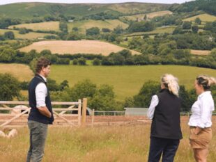
Steve
We're trying to show what we are as a people, the people who have farmed this area for many, many generations. It's a very, very special place, and these places are going to be lost very, very quickly. There has to be a realisation of, not only food production, but the social value of deep rural areas.
 The
The