https://defrafarming.blog.gov.uk/transcript-episode-3-sustainable-farming-incentive-and-land-management-plans/
Transcript: Episode 3 Sustainable Farming Incentive and Land Management Plans
Rebecca Laughton, Facilitator, Growing the Goods Test & Trial
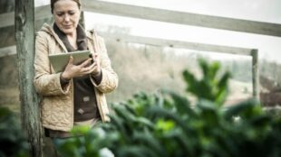
Hello, my name is Rebecca Laughton, and I work for The Landworkers’ Alliance. I'm the project facilitator for the Growing the Goods Test & Trial. The goal of Growing the Goods is to create the elements of an environmental land management scheme that could be attractive and accessible to horticultural growers.
The Growing the Goods trial involves horticulturalists from all over England, and a range of growers from the very smallest, such as Dagenham Farm, which is less than a hectare, right up to very large-scale field-scale vegetable growers, large orchards, glass houses, ornamental growers. So it really covers a huge diversity of different types of grower.
Growing the Goods is quite a comprehensive Test & Trial. The first part of it was to design a system for auditing the public goods that are delivered by a farm, and also the natural capital that's present on a farm. For that, we adapted a classification system called UK Hab Codes, which basically classifies all the different kinds of habitats in the UK and we've actually developed a set of codes to classify the habitats you'd find on a horticultural farm. We've then used a tool called the Land App, which is a GIS (Geographic Information System) mapping system.
We got half of the participants in the trial to use the Land App to map the public goods actions that they're delivering on their farm, and the other half of the participants to use a much simpler checklist approach to auditing public goods actions and natural capital.
In Spring 2021, we started testing land management plans, which are a spreadsheet-based, tabular land management plan, which starts off looking at the land parcel and then at the public goods to be delivered on that land parcel. We also have done an extra part, which was developing payment mechanisms, and then testing them.
Growers made it very clear to us that they wanted something that was really simple and easy to use, but also we needed to develop a tool that accommodated the vast diversity of the horticulture sector, so from small-scale urban farms, all the way up to huge glass houses like Vitacress, or large-scale tree fruit businesses.
A land management plan is a comprehensive document that enables a farmer or grower to show all the public goods actions that they are intending to deliver, and to cost them out and work out how much of each of those actions they intend to deliver to get an environmental land management payment. This enables us to quantify the different public goods actions, and in the design of the land management plan that we've chosen, it enables you to cross-reference them. So quite a lot of public goods actions actually deliver different categories of public goods. So for example, sowing a green manure crop, which is a crop that will fix nitrogen and add soil structure through adding organic matter, that can contribute to climate change mitigation and adaptation because it's reducing the amount of fertiliser that you need, but it's also improving soil quality, it's improving the water retention of the soil, and so it contributes to clean and plentiful water. It also contributes to thriving plants and wildlife because it creates really healthy soil.
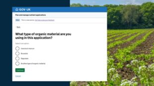
The land management plan has been designed to be used based on public goods actions and the quantity of them that would need to be delivered, and the payment rate for that quantity. The way it works is that you have a code for each public goods action and you enter it in the left hand column. So for example, for this one C1A, which is the Pathway to Peak-free Propagation, that fulfills the public goods categories, Climate Change Mitigation, Thriving Plants and Wildlife, and Clean and Plentiful Water. It would be something that would happen on the whole farm because all the seedlings on a farm would use peat-free growing media, and you would choose from this drop-down menu, which is a list of all the possible UK Habitat Codes. Then, if there was a land use change involved with the public goods action, which there isn't here, you could choose a different habitat from that same list of codes.
The parts that the grower has to fill in are the status, which is whether the public goods action is ongoing, that means that the grower is doing it already, or whether it's a new action. Then the grower would also need to fill in the current habitat and the land use change, and the quantity of the units which would be delivered.
David Knight, Pippins Farm Orchards, Pembury, Kent
I'm David Knight and this is Pippins Farm, Pembury in West Kent near Tunbridge Wells. Our farm is about 120 acres, it's about half fruit and half is grassland and woodland. Well from here, we can see quite a lot of the farm, we've got orchards pretty well all round, and some younger ones, you can see the the younger trees over there, Cameo, a North American apple; Fuji, which comes from the Far East; Braeburn, from New Zealand; Cox, from England; it's a pretty international picture here.
Hello! Hi! This is a picking train and it's got 5 bins on it on 1 trailer and the pickers are coming along emptying the buckets into the bin, and within a matter of hours that will be in a cold store or at a pack house. He's checking the fruit as it comes in and discarding anything that's not good, so hopefully over 90% of these apples will be good when they go through the pack house. So that's over two tons a day, it's a lot of apples, we get into millions quite quickly.
Last winter, I got involved looking at how horticulture might be part of ELMs (environmental land management), how it might work and how it might be paid for. So having done all that and learned quite a bit about the ELMs plan I thought I might as well go in as a pilot farm. So I'm at the start of that, it's going to take some time to experiment and to gather information.
We've looked at different things that might be included. So it covered the whole range of public access, hedge rows, trees, watercourses, soils, biodiversity.
This orchard was planted earlier this year. It’s a hedgerow system in straight lines, in single rows, and underneath we composted it this summer, although weeds are starting to grow across it. And then, in between the trees, in the alleyways, we've grassed it down with a grass mix.
Looking at ELMs we might possibly put something in here in the strip here and a wildflower mix, but it would need to be low growing because we don't want to compete with the trees. At the moment we have to use herbicides in between the trees here, in the alleyway. There are some schemes where wildflower mixes have been put in, maybe every 3rd row or 4th row because it's quite expensive, and that would be good for pollination and insects and general biodiversity.
We've had some templates we had to fill in, there's a land management plan which is based on a farm map and some people did that on the computer online. The mapping is very sophisticated and you can go on sites like Magic where you can get all the different things like nitrate vulnerable zones, AONBs (Area of Outstanding Natural Beauty), soil types. I did mine as a physical map, which I just filled in and photocopied. I just used the Land Registry map that I got from the RPA, Rural Payments Agency, some years ago.
I've always been keen on the environment and trying to be a good steward of the land, so anything to do with that is something I'm trying to be involved with. We’ve got to see how ELMs fits in because we can't hamper our commercial horticultural enterprise with a scheme that's only going to produce a very small amount of income. They've got to work together and be complementary and not be in opposition, so that's really what we're going to find out.
Leah Mathias-Collins, Vitacress Herbs, Chichester, West Sussex
My name is Leah Mathias-Collins. I'm the Group Environment Manager here at Vitacress. Today we're standing at Vitacress Herbs. Here we produce pot herbs and cut herbs for all the UK supermarkets, 20 million pots of herbs a year, all in our glasshouse facilities here.
We've had to map our whole site, what buildings are there, what growing operations and then what habitats or any other land uses, and develop a land management plan, all the things we'd like to do to improve the environment.
The simplest level for us are our habitat management, schemes we'd like to put in place for wildlife. Here for example, we have a ditch which supports a population of water voles and we'd like through ELMs to actually enhance that habitat and possibly extend this ditch line all the way down to the discharge point in the Chichester flood relief channel.
So it's very exciting to have water voles on site. Having a declining species that we could actually support and improve its habitat and linkages to the wider landscape.
This is our land management plan map, we use the Land App for this. The import from the Rural Payments Agency of our land boundaries and then we had to plot the features on the site. So we plotted our growing areas, built up areas, and all the various habitat areas. We actually used our phase one habitat survey to help us with this as that was already there. This then linked to a land management plan so actually what you can see on here are the actual management pieces that we want to do on our site, so they're already plotted and linked to the land management plan, which is a spreadsheet, and then each of those pieces linked on the map are listed with their area, so all the data is taken directly which is great, and then we have to fill in what habitat code that is, what's the land use at the moment, what public goods action we wanted to carry out on that. So for example, we're looking at phasing out peat in our glass houses, we then link that to the 25-year environment plan and the resources, the actual actions, so this is about using resources more sustainably, and then we had to say what the change of management was, so these are drop-down lists with examples or what the land use change was. So for peat it's a change in management, and then where are we on the process, when do we aim to complete, and then we have to look at what are the barriers, how do we replace peat, we need something that will replace it fully and do all the job that peat does such as holding nutrients, water and reducing pathogens, and then the barrier obviously being funding.
So that's more of a growing operation, and then we did also list our uh requirements for habitat work, so for example, we've got a butterfly walk on our site. We put the current habitat description in which is Neutral Grassland from the drop down, and then we link that again to the public goods, and then we talk about our barriers to ensure that nothing grows directly against our glasshouse walls, so it's it's a case of actually how do we make sure we can put this habitat in place without being detrimental to the glass house operation.
Having a really comprehensive map of the site with everything that goes on on the site was a really useful exercise, and then the land management plan was really useful in terms of linking a map to management actions because it's no good just having an action plan if you actually can't see where these improvements are going to take place.
Alice Holden, Dagenham Starter Farm, East London
Hello, my name is Alice Holden, and I'm head grower at Growing Communities’ Dagenham Farm, we're a 1.77-acre market garden in Dagenham, East London.
This is Dave, he's a fantastic volunteer, he's been coming to the farm since 2012. I wouldn't have survived without him. He’s local and we've had lots of volunteers here in the last 10 years, local people, a huge range of people come for all sorts of reasons, a break from their day to day.
We have lots of managed bits of the farm but also lots of wild bits, and they're good for biodiversity and they host predators that help balance our pests.
These are endive, and underneath I've just sewn some rocket and mizuna from saved seed heads. I'm mixing up crops more and more because different crops put different things into the soil, so we're trying to create biodiversity in the soil below ground as well as biodiversity above ground, and that is generally a way of just maintaining health and a diverse ecosystem.
This farm is unusual because it's in Dagenham, which is in East London. So you can see the polytunnels and then there's a tower block behind us, we're in a very urban environment.
I really felt it was important to try and get smaller scale, market garden type farms recognised by the scheme, the new ELM schemes, this is the most sustainable form of food production, growing edible plants in an organic way, it relies on very sustainable methods and is very productive.
So I've tested two versions of this tool, essentially it involved trying to map what we do on the land and give it value of its public good. A land management plan is useful and valuable to me because it gives me an overview of quantifying the positive impacts that we're creating through using the kind of techniques we're doing here.
The tool has been amended and developed to make it less difficult to use and less time consuming for farmers like me. The main input is working at the unit relating to each category and to be honest they're records we have to keep mostly already for our organic certification, so they're things that I already had to hand.
I think going through this process has really helped me quantify what we already do and it would be really good to have those things recognised in terms of the social value and the sustainable methods we use for food production. I think we're now very aware that we are a tipping point state in terms of biodiversity so we need to reward the farmers that farm sustainably and build biodiversity at the same time as grow food so they can continue doing that.